Types of US Maps Available
Political USA Maps
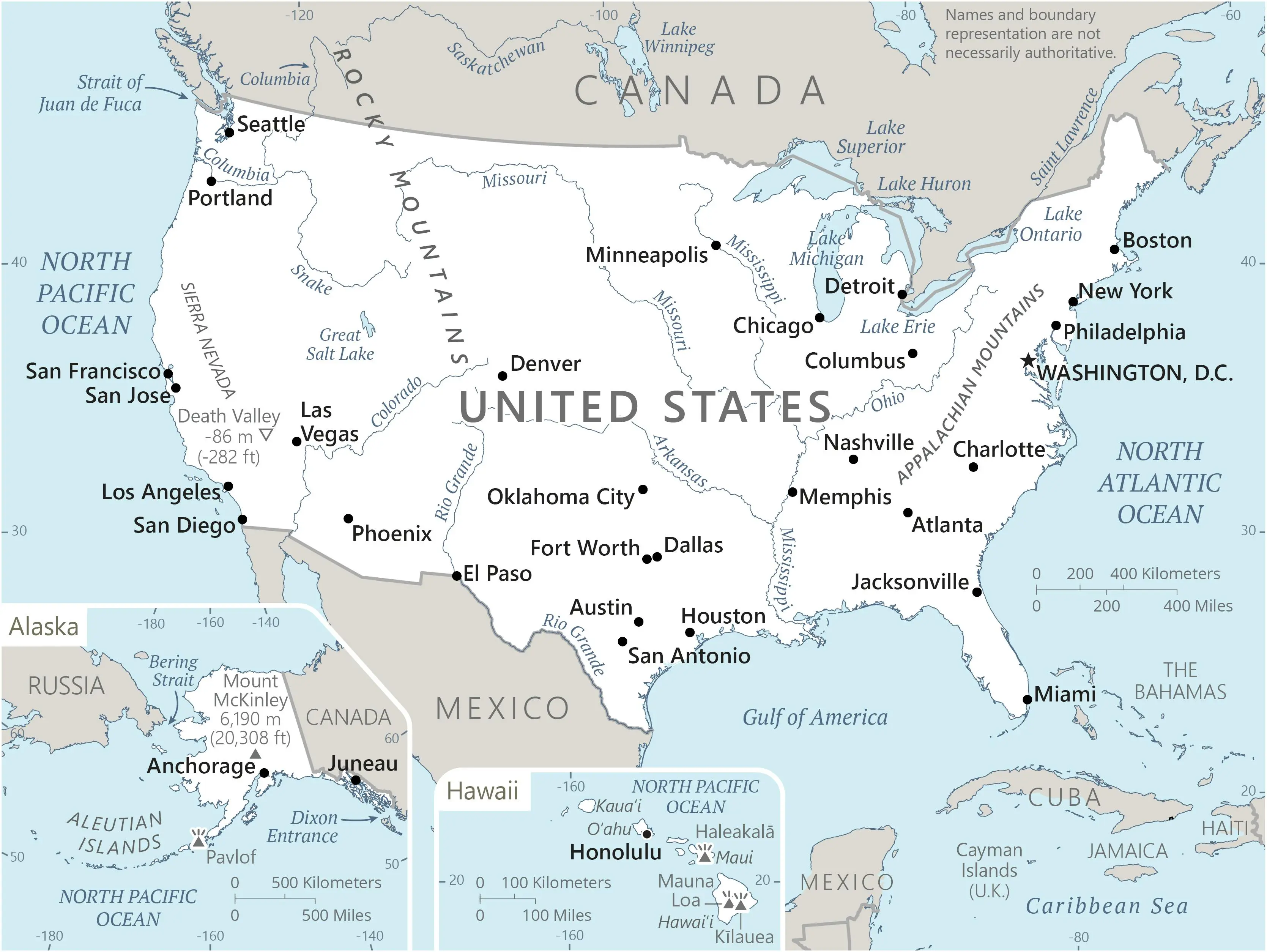
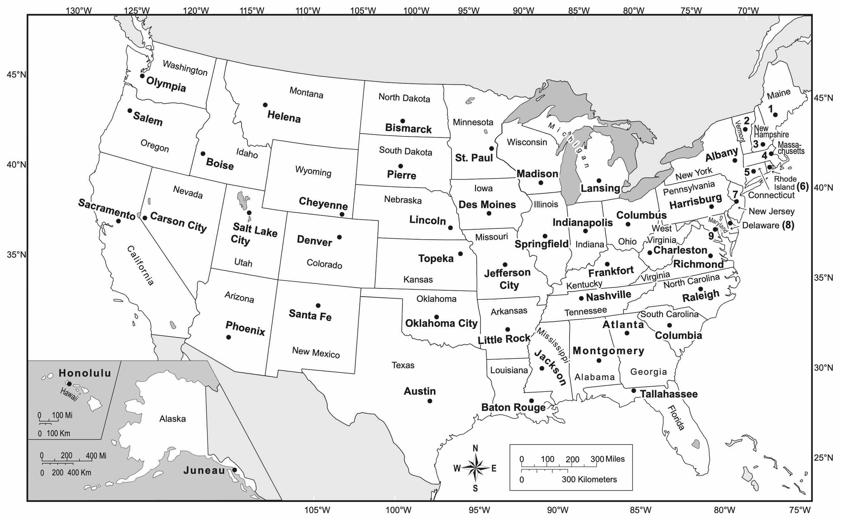
Our political USA map with states and capitals clearly shows state boundaries, major cities, and capital locations. These maps are perfect for educational purposes and reference, highlighting administrative divisions rather than physical features. The political USA map is the most commonly used variant for classroom settings and government reference.
Physical USA Maps
Physical maps of the USA emphasize natural landscape features such as mountains, rivers, lakes, and elevations. These maps use color gradients to represent elevation changes, from the Appalachian Mountains in the east to the Rocky Mountains in the west, and the vast plains in between. Physical USA maps are ideal for understanding the country's diverse terrain.
Road Maps and Highways
Our USA map with cities highlights major interstate highways, state routes, and urban centers. Perfect for trip planning, these maps show connections between major metropolitan areas and estimated travel distances. Road maps of the USA are essential for understanding the country's transportation network.
National Parks Maps
Discover America's natural treasures with our national parks USA map. This specialized map shows the location of all 63 national parks across the USA, from Acadia in Maine to Zion in Utah. Each park is marked with its establishment date and key features.
Time Zone Maps
The United States spans six time zones, from Eastern to Hawaii-Aleutian. Our time zones USA map clearly delineates these regions, helping you understand time differences when communicating or traveling across the country.
Historical USA Maps
Trace the evolution of the United States with our historical USA maps from 1800, 1850, and 1900. These maps show territorial expansion, state formation, and boundary changes throughout American history. Historical USA maps are invaluable for understanding the country's development.
State-by-State Guide to the USA Map
Northeastern States
The Northeast region of the USA map includes Maine, New Hampshire, Vermont, Massachusetts, Rhode Island, Connecticut, New York, New Jersey, and Pennsylvania. This historically significant region was among the first settled by Europeans and contains many of America's oldest cities. Notable features include the Appalachian Mountains, the Great Lakes borders, and major metropolitan areas like New York City and Boston. The capital of New York is Albany, while Pennsylvania's capital is Harrisburg, though Philadelphia is its largest city.
Southern States
The Southern states on the USA map include Virginia, West Virginia, Kentucky, Tennessee, North Carolina, South Carolina, Georgia, Florida, Alabama, Mississippi, Louisiana, Arkansas, and Texas. This diverse region spans from the Atlantic Ocean to the Rio Grande along the Mexican border. The region features varied geography from the Appalachian foothills to Florida's tropical climate. Major capitals include Richmond (Virginia), Atlanta (Georgia), and Austin (Texas). The Gulf Coast states are prone to hurricanes, while inland areas have rich agricultural traditions.
Midwestern States
America's heartland on the USA map includes Ohio, Indiana, Illinois, Michigan, Wisconsin, Minnesota, Iowa, Missouri, North Dakota, South Dakota, Nebraska, and Kansas. This region is characterized by vast plains, the Great Lakes, and major river systems including the Mississippi and Missouri. The Midwest is America's agricultural center, producing much of the nation's corn, wheat, and soybeans. Major capitals include Columbus (Ohio), Indianapolis (Indiana), and Springfield (Illinois), while Chicago stands as the region's largest metropolitan area.
Western States
The Western states on the USA map include Montana, Wyoming, Colorado, New Mexico, Idaho, Utah, Arizona, Nevada, and Oklahoma. This region features dramatic landscapes including the Rocky Mountains, the Grand Canyon, and vast deserts. The West has a rich indigenous heritage and was the last continental region to be extensively settled by non-native populations. Major capitals include Denver (Colorado), Salt Lake City (Utah), and Phoenix (Arizona), which is also one of America's fastest-growing metropolitan areas.
Pacific States
The Pacific region on the USA map includes Washington, Oregon, and California. This coastal region features diverse ecosystems from temperate rainforests in the north to Mediterranean climates in the south. The Sierra Nevada mountains and Cascade Range dominate the eastern portions of these states. Major capitals include Olympia (Washington), Salem (Oregon), and Sacramento (California), though Seattle, Portland, and Los Angeles are the largest cities respectively.
Alaska and Hawaii
These non-contiguous states present unique features on the USA map. Alaska, America's largest state by area, spans vast northern territories with mountain ranges, tundra, and Arctic regions. Its capital is Juneau. Hawaii, a volcanic island chain in the Pacific, is America's southernmost state with a tropical climate and unique cultural heritage. Honolulu serves as its capital. Both states joined the union in 1959 as the 49th and 50th states respectively.
Frequently Asked Questions about USA Maps
How many states are on a USA map?
A complete USA map with states includes all 50 states. These consist of 48 contiguous states in the mainland, plus Alaska in the northwest of the continent and Hawaii in the Pacific Ocean. Each state on the USA map has its own unique shape, size, and geographic features.
What is the difference between a political and physical USA map?
A political USA map primarily shows administrative boundaries like states, counties, and cities, with capitals and major urban centers clearly labeled. A physical USA map instead emphasizes natural features like mountains, rivers, lakes, and elevation changes, often using color gradients to represent topography.
Where can I download a high-resolution blank USA map?
You can download free high-resolution blank USA maps from our blank maps section. These USA map outlines are perfect for educational purposes, presentations, or projects requiring a clean template of the United States.
How many time zones does the USA map cover?
A complete time zones USA map shows six standard time zones: Eastern, Central, Mountain, Pacific, Alaska, and Hawaii-Aleutian. Some states, like Kentucky and Tennessee, span multiple time zones, which is clearly shown on our specialized time zone maps.
How has the USA map changed historically?
Historical USA maps from 1800, 1850, and 1900 show dramatic changes in territorial boundaries. The USA map from 1800 had only 17 states, the USA map from 1850 showed expansion to the Pacific, and by 1900, most modern state boundaries were established. Explore these changes in our historical maps section.
Which states are the largest and smallest on the USA map?
On any USA map with states, Alaska is visibly the largest state by area (663,300 square miles), often shown in an inset due to its size. Rhode Island is the smallest state (1,034 square miles). The size contrast between these states on the USA map is striking - Alaska is more than 600 times larger than Rhode Island.