Evolution of the USA Map Through History
Historical USA maps provide a fascinating window into the nation's territorial expansion and development. From the early days of independence to the continental power of the 20th century, these old USA maps chronicle the dramatic transformation of American geography.
Our collection focuses on three pivotal periods in American history: 1800, when the young republic was still confined to territory east of the Mississippi; 1850, after major western expansion had reshaped the nation; and 1900, when the continental United States had reached its modern form. Each historical USA map reveals not just changing borders, but the story of America's growth and identity.
These public domain historical maps have been digitally restored and enhanced for clarity while preserving their authentic character. They serve as both historical documents and educational resources for understanding how the USA map has evolved over time.
USA Map 1800: The Early Republic
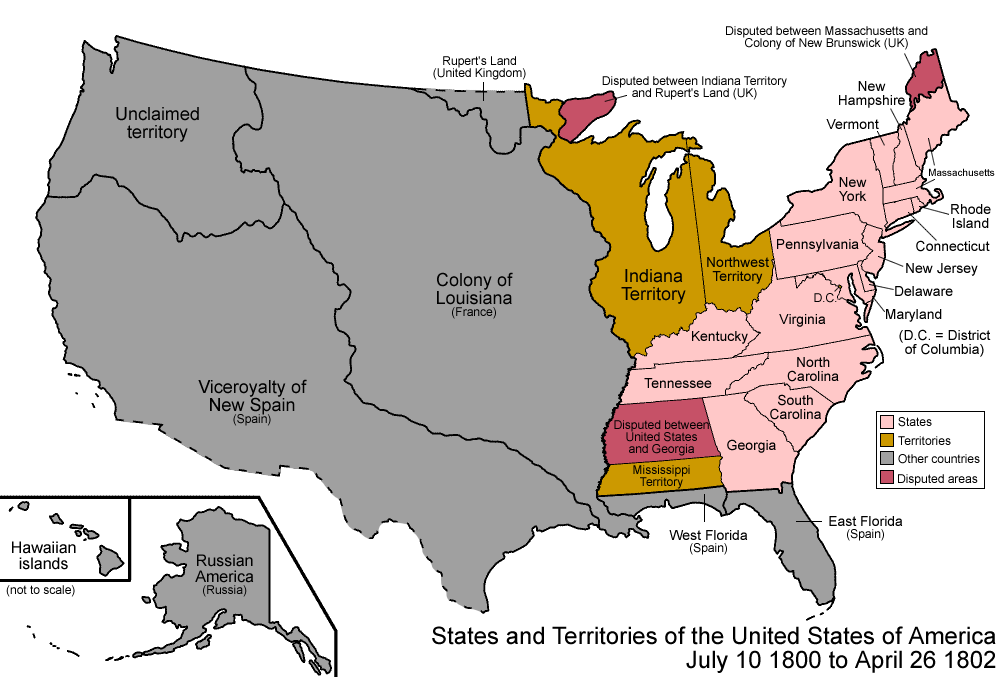
In 1800, the USA map looked drastically different from today. Only 17 states had been admitted to the Union, all located east of the Mississippi River. The old USA map from 1800 shows a nation still largely confined to its original territories, with vast regions yet to be explored and settled by American citizens.
Key features of the 1800 USA map include:
- Original 13 Colonies: The core eastern states that formed after the American Revolution
- Vermont, Kentucky, Tennessee, and Ohio: The first wave of new states being formed
- Northwest Territory: The organized territory that would later become Michigan, Indiana, Illinois, Wisconsin, and part of Minnesota
- Mississippi Territory: The region that would later become Alabama and Mississippi
- Louisiana: Still under French control (though soon to be purchased in 1803)
- Spanish Florida: The territories of East and West Florida under Spanish control
- Vast "Unknown" Western Regions: Territories claimed but largely unexplored by the United States
This historical USA map shows a young nation at the beginning of the 19th century, poised for the remarkable territorial expansion that would define the coming decades. The Louisiana Purchase would soon double the nation's size, setting the stage for westward expansion.
USA Map 1850: Manifest Destiny and Westward Expansion
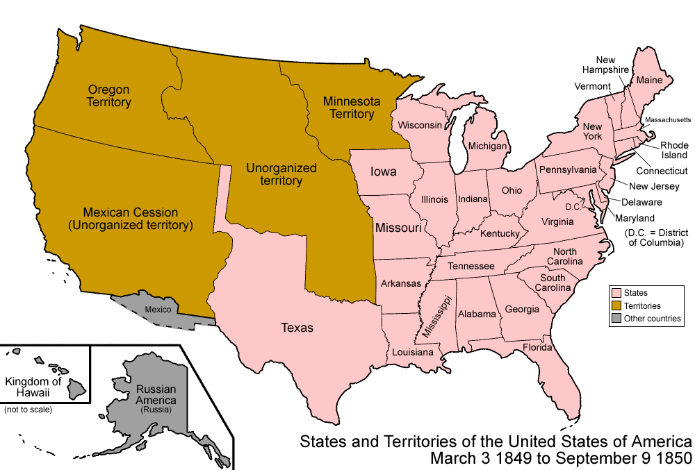
By 1850, the USA map had transformed dramatically. The nation had expanded all the way to the Pacific Ocean, fulfilling what many Americans of the era called "Manifest Destiny" - the belief that the United States was destined to spread across the continent. This USA map from 1850 shows a nation in the midst of rapid growth and territorial acquisition.
Key features of the 1850 USA map include:
- 30 States: The Union had grown to 30 states, with California having just been admitted following the Gold Rush
- Texas: Recently annexed in 1845 after its war of independence from Mexico
- Oregon Territory: Acquired through a treaty with Great Britain in 1846
- Mexican Cession: The vast southwestern territories gained after the Mexican-American War (1846-1848)
- Utah and New Mexico Territories: Recently organized after the Compromise of 1850
- Unorganized Territory: The central plains region not yet formally organized
- Disputed Borders: Several border disputes still in negotiation
This historical USA map captures a pivotal moment in American expansion, when the nation had achieved its coast-to-coast ambition but was still organizing its newly acquired territories. The 1850s would prove to be a decade of increasing sectional tension, as the question of whether these new territories would permit slavery intensified divisions between North and South.
USA Map 1900: Industrial America at the Turn of the Century
By 1900, the USA map had mostly taken its modern shape. The continental United States consisted of 45 states, with only Oklahoma, New Mexico, Arizona, Alaska, and Hawaii yet to join the Union. This USA map from 1900 shows a nation transformed from a collection of coastal colonies into a continental power at the beginning of the 20th century.
Key features of the 1900 USA map include:
- 45 States: The majority of today's states had been admitted, with the last contiguous territories being prepared for statehood
- Industrial Centers: Major industrial regions in the Northeast and Great Lakes areas
- Transcontinental Railroads: The network of railroads connecting the country coast-to-coast
- Indian Territories: The remaining designated lands for Native American nations
- Recent Acquisitions: Hawaii had been annexed in 1898 but not yet made a state
- Overseas Territories: New possessions like Puerto Rico, Guam, and the Philippines following the Spanish-American War
- Settled Borders: Nearly all border disputes with neighboring countries had been resolved
This historical USA map represents the nation at the dawn of its emergence as a global power. The frontier had officially closed, according to the 1890 census, and the United States was increasingly looking beyond its borders, particularly to the Pacific. The industrial might that would define America in the 20th century was already visible in the northeastern manufacturing belt and the growing cities across the country.
Timeline of US Territorial Expansion
The dramatic changes visible in these historical USA maps occurred through a series of territorial acquisitions, treaties, and conflicts that expanded the country from a collection of coastal states to a transcontinental nation.
Treaty of Paris ends the Revolutionary War and establishes U.S. independence. The new nation's territory extends from the Atlantic Ocean to the Mississippi River, and from the Great Lakes to Spanish Florida.
Louisiana Purchase: The United States purchases approximately 827,000 square miles of territory from France for $15 million, doubling the size of the young nation.
Adams-Onís Treaty: Spain cedes Florida to the United States and defines the boundary between U.S. territory and Spanish possessions in the West.
Texas Annexation: The Republic of Texas, which had won independence from Mexico in 1836, is annexed by the United States as the 28th state.
Oregon Treaty: The United States and Great Britain settle their competing claims to the Oregon Territory, establishing the 49th parallel as the northern boundary of the U.S.
Mexican Cession: Following the Mexican-American War, Mexico cedes vast territories in the Southwest, including California, Nevada, Utah, and parts of Colorado, Arizona, New Mexico, and Wyoming.
Gadsden Purchase: The United States purchases a strip of land from Mexico in what is now southern Arizona and New Mexico, primarily to facilitate a southern transcontinental railroad route.
Alaska Purchase: The United States purchases Alaska from Russia for $7.2 million, adding over 586,000 square miles of territory.
Hawaiian Annexation: The United States annexes the Republic of Hawaii following a controversial overthrow of the Hawaiian monarchy.
By the turn of the century, the continental United States had nearly reached its current form, with only a few territories still waiting for statehood.
Historical Significance of USA Map Evolution
Nation Building and Identity
The evolution of the USA map tells the story of national identity formation. Each expansion represented not just new territory but new populations, resources, and challenges that shaped what it meant to be American. The dramatic changes visible in comparing a USA map from 1800 to 1850 to 1900 illustrate a nation constantly redefining itself.
Indigenous Displacement
Historical USA maps also document the displacement of Native American nations. As state boundaries were drawn and territories organized, indigenous lands were increasingly confined to smaller reservations. The changing map represents both American expansion and the complex, often tragic history of U.S.-Native American relations.
Economic Development
Each expansion represented new economic opportunities. The acquisition of New Orleans and the Mississippi River in the Louisiana Purchase secured vital trade routes. The California Gold Rush following Mexican cession brought wealth and settlers westward. By 1900, the transcontinental railroads visible on the USA map had created a unified national market.
Global Power Status
The territorial expansion documented in these historical USA maps laid the foundation for America's emergence as a global power in the 20th century. With secure borders, abundant resources, and a span from Atlantic to Pacific, the United States was positioned for the international role it would play after 1900.
Educational Resources
Our historical USA maps are valuable educational tools for students, teachers, and history enthusiasts. Here are some ways to use these resources:
Classroom Activities
- Comparative Analysis: Compare USA maps from 1800, 1850, and 1900 to identify changes in boundaries, states, and territories
- Timeline Projects: Create detailed timelines of U.S. territorial acquisitions using these historical USA maps as visual references
- State Formation Study: Track when and how each state entered the Union using the historical progression shown in these maps
- Historical Context: Discuss how events like the Civil War, Industrial Revolution, and Native American relations relate to the changing USA map
Available Downloads
All our historical USA maps are available as high-resolution downloads in multiple formats:
- JPG format for digital presentations and projects
- PDF format for printing and educational handouts
- PNG format with transparent backgrounds for creative projects