Map of the United States with All 50 State Names
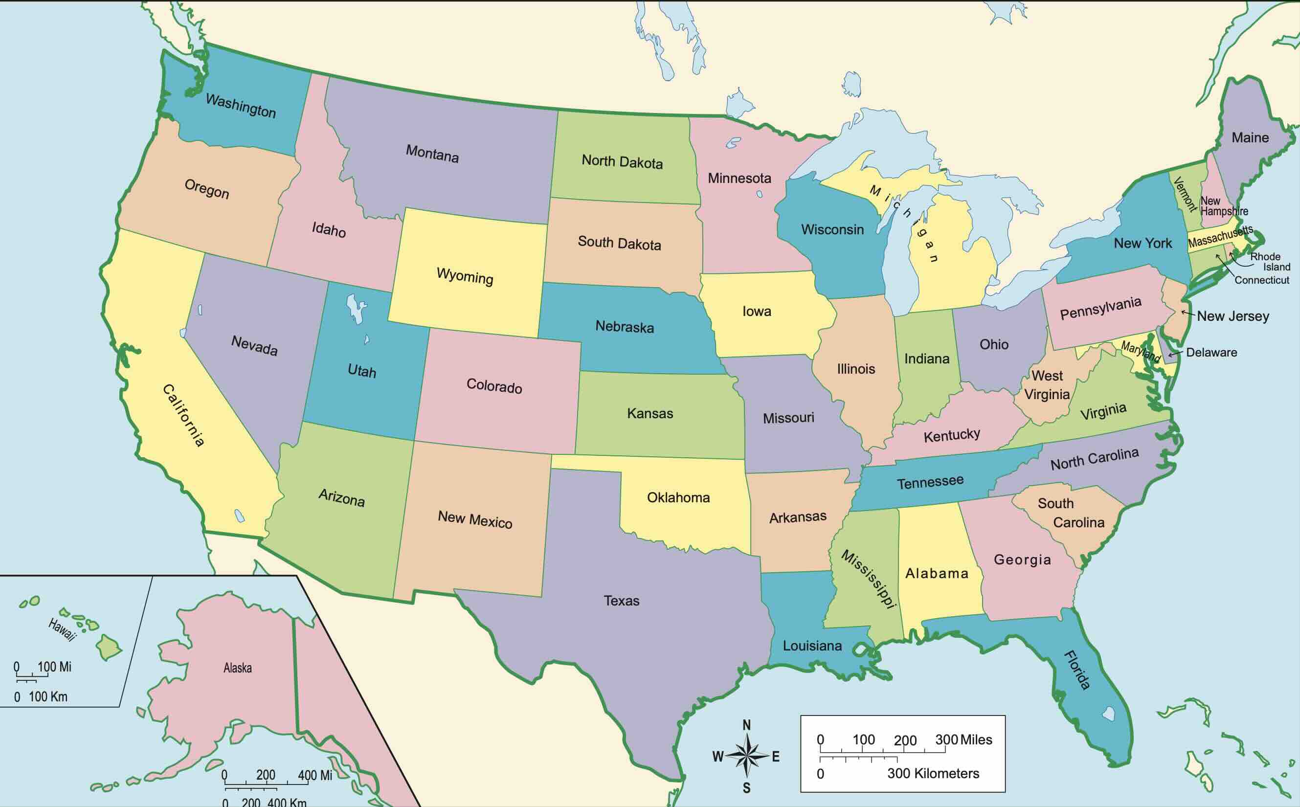
This map of the USA shows every state clearly labeled with its name, so you can see at a glance where each state sits - from Maine in the far north-east to California on the Pacific coast, with Alaska and Hawaii shown in insets. Below the map you will find an interactive version you can zoom and click, a complete table of all 50 states with their capitals, abbreviations and largest cities, and a region-by-region list.
Need a copy for the classroom or office? Get the free printable US map with states labeled (PDF, A4 and Letter), or a blank US map with no labels for practice.
Interactive USA Map with States and Capitals
Hover over any state to see its name, abbreviation and capital. Click a state to open its detailed map with cities, counties and landmarks.
All 50 US States: Names, Abbreviations, Capitals and Largest Cities
The table lists every state on the US map in alphabetical order with its official two-letter postal abbreviation, state capital, largest city, population and land area. Click a state name to open its own map.
| State | Abbr. | Capital | Largest City | Population | Area |
|---|---|---|---|---|---|
| Alabama | AL | Montgomery | Birmingham | 5,024,279 | 52,420 sq mi |
| Alaska | AK | Juneau | Anchorage | 733,391 | 665,384 sq mi |
| Arizona | AZ | Phoenix | Phoenix | 7,151,502 | 113,990 sq mi |
| Arkansas | AR | Little Rock | Little Rock | 3,011,524 | 53,179 sq mi |
| California | CA | Sacramento | Los Angeles | 39,538,223 | 163,695 sq mi |
| Colorado | CO | Denver | Denver | 5,773,714 | 104,094 sq mi |
| Connecticut | CT | Hartford | Bridgeport | 3,605,944 | 5,543 sq mi |
| Delaware | DE | Dover | Wilmington | 989,948 | 2,489 sq mi |
| Florida | FL | Tallahassee | Jacksonville | 21,538,187 | 65,758 sq mi |
| Georgia | GA | Atlanta | Atlanta | 10,711,908 | 59,425 sq mi |
| Hawaii | HI | Honolulu | Honolulu | 1,455,271 | 10,932 sq mi |
| Idaho | ID | Boise | Boise | 1,839,106 | 83,569 sq mi |
| Illinois | IL | Springfield | Chicago | 12,812,508 | 57,914 sq mi |
| Indiana | IN | Indianapolis | Indianapolis | 6,785,528 | 36,420 sq mi |
| Iowa | IA | Des Moines | Des Moines | 3,190,369 | 56,273 sq mi |
| Kansas | KS | Topeka | Wichita | 2,937,880 | 82,278 sq mi |
| Kentucky | KY | Frankfort | Louisville | 4,505,836 | 40,408 sq mi |
| Louisiana | LA | Baton Rouge | New Orleans | 4,657,757 | 52,378 sq mi |
| Maine | ME | Augusta | Portland | 1,362,359 | 35,384 sq mi |
| Maryland | MD | Annapolis | Baltimore | 6,177,224 | 12,406 sq mi |
| Massachusetts | MA | Boston | Boston | 7,029,917 | 10,554 sq mi |
| Michigan | MI | Lansing | Detroit | 10,037,261 | 96,714 sq mi |
| Minnesota | MN | Saint Paul | Minneapolis | 5,737,915 | 86,936 sq mi |
| Mississippi | MS | Jackson | Jackson | 2,961,279 | 48,432 sq mi |
| Missouri | MO | Jefferson City | Kansas City | 6,196,010 | 69,707 sq mi |
| Montana | MT | Helena | Billings | 1,084,225 | 147,040 sq mi |
| Nebraska | NE | Lincoln | Omaha | 1,961,504 | 77,348 sq mi |
| Nevada | NV | Carson City | Las Vegas | 3,104,614 | 110,572 sq mi |
| New Hampshire | NH | Concord | Manchester | 1,377,529 | 9,349 sq mi |
| New Jersey | NJ | Trenton | Newark | 9,288,994 | 8,723 sq mi |
| New Mexico | NM | Santa Fe | Albuquerque | 2,117,522 | 121,590 sq mi |
| New York | NY | Albany | New York City | 20,201,249 | 54,555 sq mi |
| North Carolina | NC | Raleigh | Charlotte | 10,439,388 | 53,819 sq mi |
| North Dakota | ND | Bismarck | Fargo | 779,094 | 70,698 sq mi |
| Ohio | OH | Columbus | Columbus | 11,799,448 | 44,826 sq mi |
| Oklahoma | OK | Oklahoma City | Oklahoma City | 3,959,353 | 69,899 sq mi |
| Oregon | OR | Salem | Portland | 4,237,256 | 98,379 sq mi |
| Pennsylvania | PA | Harrisburg | Philadelphia | 13,002,700 | 46,054 sq mi |
| Rhode Island | RI | Providence | Providence | 1,097,379 | 1,545 sq mi |
| South Carolina | SC | Columbia | Charleston | 5,118,425 | 32,020 sq mi |
| South Dakota | SD | Pierre | Sioux Falls | 886,667 | 77,116 sq mi |
| Tennessee | TN | Nashville | Nashville | 6,910,840 | 42,144 sq mi |
| Texas | TX | Austin | Houston | 29,145,505 | 268,596 sq mi |
| Utah | UT | Salt Lake City | Salt Lake City | 3,271,616 | 84,897 sq mi |
| Vermont | VT | Montpelier | Burlington | 643,077 | 9,616 sq mi |
| Virginia | VA | Richmond | Virginia Beach | 8,631,393 | 42,775 sq mi |
| Washington | WA | Olympia | Seattle | 7,705,281 | 71,298 sq mi |
| West Virginia | WV | Charleston | Charleston | 1,793,716 | 24,230 sq mi |
| Wisconsin | WI | Madison | Milwaukee | 5,893,718 | 65,496 sq mi |
| Wyoming | WY | Cheyenne | Cheyenne | 576,851 | 97,813 sq mi |
US States by Region
The Census Bureau groups the states on the map into four regions. Knowing the regions makes it much easier to remember where each state is located.
Northeast (9 states)
Maine (ME), New Hampshire (NH), Vermont (VT), Massachusetts (MA), Rhode Island (RI), Connecticut (CT), New York (NY), New Jersey (NJ), Pennsylvania (PA).
Midwest (12 states)
Ohio (OH), Indiana (IN), Illinois (IL), Michigan (MI), Wisconsin (WI), Minnesota (MN), Iowa (IA), Missouri (MO), North Dakota (ND), South Dakota (SD), Nebraska (NE), Kansas (KS).
South (16 states)
Delaware (DE), Maryland (MD), Virginia (VA), West Virginia (WV), Kentucky (KY), Tennessee (TN), North Carolina (NC), South Carolina (SC), Georgia (GA), Florida (FL), Alabama (AL), Mississippi (MS), Louisiana (LA), Arkansas (AR), Oklahoma (OK), Texas (TX).
West (13 states)
Montana (MT), Wyoming (WY), Colorado (CO), New Mexico (NM), Idaho (ID), Utah (UT), Arizona (AZ), Nevada (NV), Washington (WA), Oregon (OR), California (CA), Alaska (AK), Hawaii (HI).
How to Read a Map of the United States
Contiguous states and the insets
The 48 contiguous states stretch about 2,800 miles from the Atlantic to the Pacific. Alaska (north-west of Canada) and Hawaii (in the central Pacific) are far from the mainland, so almost every US map draws them in small inset boxes; they are not actually located south-west of California.
State capitals vs largest cities
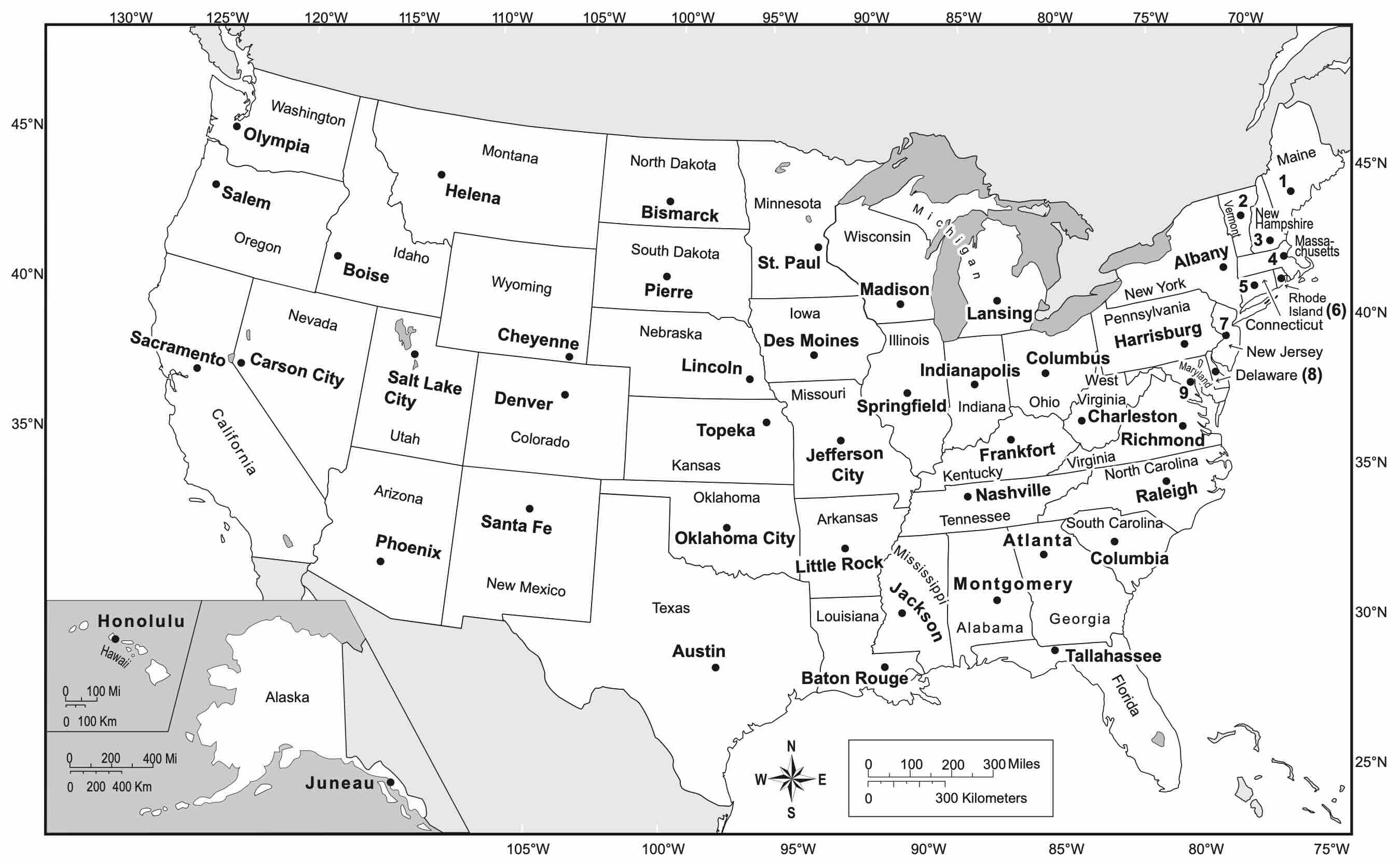
In most states the capital is not the biggest city. New York's capital is Albany, not New York City; California's is Sacramento, not Los Angeles; Texas is governed from Austin, not Houston. On the map above, capitals are marked with a star, and the table lists both the capital and the largest city for every state.
State borders
Many western borders follow straight lines of latitude and longitude, which is why Colorado, Wyoming and Utah look like rectangles. Eastern borders were mostly drawn along rivers and mountain ranges - the Mississippi River alone forms part of the border of ten states.
Frequently Asked Questions
How many states are on the map of the United States?
The United States map shows 50 states plus the District of Columbia (Washington, DC), which is a federal district and not a state. 48 states are contiguous; Alaska and Hawaii are usually shown in insets in the lower left corner of the map.
Which state names are hardest to find on a US map?
The small New England states are the usual trouble spots: Rhode Island, Connecticut, Delaware, New Jersey, Massachusetts, Vermont and New Hampshire are all packed into the north-east corner. On a labeled map their names are often abbreviated (RI, CT, DE, NJ, MA, VT, NH) or shown with leader lines.
What is the two-letter abbreviation for each state?
Every state has an official USPS two-letter code, for example CA for California, TX for Texas, NY for New York and FL for Florida. The full list of all 50 abbreviations is in the table above.
Can I download this US map with states labeled?
Yes. A free printable version of the labeled United States map, with and without capitals, is available as a PDF on our printable labeled US map page in A4 and US Letter sizes.
Which is the largest and which is the smallest US state?
Alaska is by far the largest state at 665,384 square miles; Texas is the largest of the contiguous states. Rhode Island is the smallest at 1,545 square miles, followed by Delaware and Connecticut.